
Hurricane Alex predicted to bring rain to South Central Texas through Friday
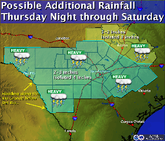
National Weather Service map
National Weather Service map
(June 30, 2010)--As Hurricane Alex makes landfall Wednesday, more moisture will push onshore and move into South Central Texas. Scattered showers and thunderstorms were predicted through Wednesday ahead of Alex. Because no major impact is anticipated in the San Antonio area, UTSA will be open and operating as usual.
Three to four inches of rain are possible for South Central Texas with the potential for locally heavy rain and some isolated flash flooding of streets and small creeks. Some areas of South Texas could receive six inches or more over the next several days.
Breezy conditions of 15-30 miles per hour may occur south of a line from Del Rio to San Antonio to Cuero. The strongest winds of 20-30 miles per hour likely were predicted to occur Wednesday night with some slightly higher gusts. The storm was predicted to make landfall early Thursday and the threat of heavy rainfall could continue through Friday.
Any weather updates will be posted on UTSA Today.
------------------------------
Weather resources
- National Weather Service
- San Antonio Flood Emergency (S.A.F.E.) System
- City of San Antonio Public Works Street Closures (updated regularly)
Events
This event will acknowledge graduating seniors from the McNair Scholars program at UTSA before inducting the new cohort of scholars into the program.
North Paseo Building (NPB 5.140), Main CampusAt this memorable celebration, UTSA graduates will be introduced one-by-one to cross the stage and accept their doctoral degrees.
Arts Building Recital Hall, Main CampusRoadrunner Walk is an event for graduating students to have a memorable walk on campus to celebrate an important milestone and their achievements. Graduates will walk along the Paseo while being celebrated by the UTSA community, friends, and family members.
Student Union Paseo, Main CampusCelebrate the accomplishments of College of Education and Human Development, College for Health, Community and Policy, College of Sciences and University College.
Alamodome, 100 Montana St.Celebrate the accomplishments of Alvarez College of Business, College of Liberal and Fine Arts and Klesse College of Engineering and Integrated Design.
Alamodome, 100 Montana St.