Tibetan Plateau Research
Remote Sensing The Third Pole: Tibetan Plateau
The Tibetan Plateau (TP) in central Asia has an average elevation of more than 4000 m asl and an area of approximately 2,500,000 km2, and is now called "the Third Pole" of the Earth and the "Asian water tower" with the largest ice mass outside the north and south polar regions. The 36,800 glaciers on the TP cover an area of 49,873 km2 (~ 2% of the total area) and are distributed over the major mountain ranges (Fig. 1). These glaciers provide fresh water resources for over 1 billion people through feeding the river systems. As a whole, the TP has undergone warming in the past three decades, especially in winter; the temperature rise of 0.3°C per decade is twice the global warming rate. The environmental influence of global warming on the TP is evident, including accelerating glaciers melt throughout almost the entire TP, permafrost degradation, and increasing temperature extremes. There are more than 1500 lakes in the TP and most of them are glacier lakes, meaning snow/glacier-melt water is the major source of water for those lakes. It is impractical to monitor all glaciers, snow cover, and lake changes over the entire TP using field based point measurements, satellite remote sensing provides a powerful way to monitor and study their changes.
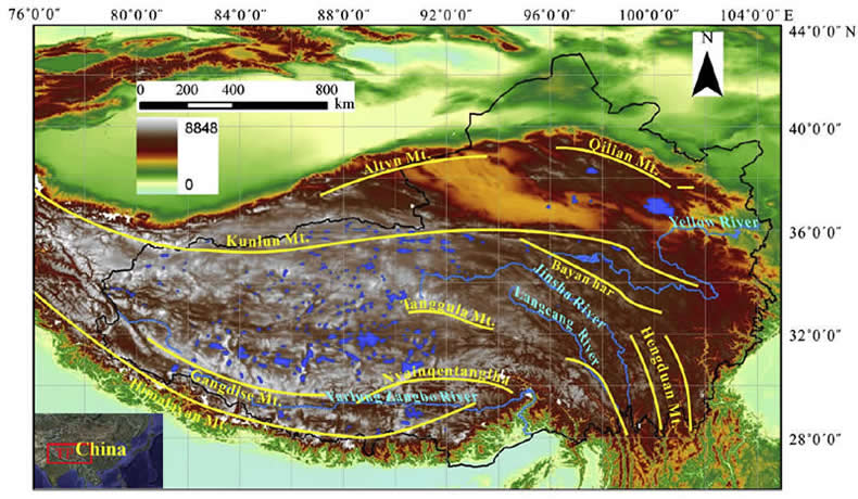
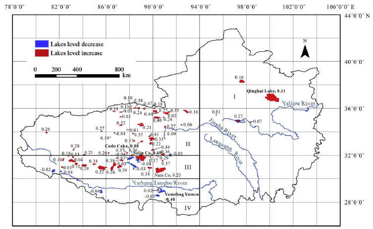
Fig. 1
upper: Location of Tibetan Plateau with regional outline (black polygon), major mountain ranges (yellow lines), and the largest rivers (blue lines). Elevation data are from NASA's SRTM DEM. Blue polygons represent 261 major (large) lakes delineated from mosaicked MODIS snow cover images. (kindly provided by Tiangang Liang at Lanzhou University, China)
bottom: 84% of lakes with lake level increase (0.23m/year). (Source: Zhang et al., 2011)
Objective
The objective of the LRSG group for the TP study, in collaboration with Lanzhou University, Institute of Tibetan Plateau Research, China University of Geosciences, and East China Institute of Technology, is:
- Sustainable water resources in Tibetan Plateau, through studying change of glacier lakes, glaciers, and snow cover, using remote sensing, field-based measurements, and modeling
Newsroom Highlights
SPIE Newsroom highlights our recent works (December 8, 2011): Rising lake levels indicate accelerated glacier melting


