Scientific Projects
Ice Mass Balance Buoys
Participants: S.F. Ackley, C. Geiger
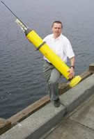
We plan to deploy thirteen instrumented autonomous buoys; three will be mass balance buoys and the other ten will be position buoys. The instrumentation on these buoys consists of a thermistor string, acoustic sensors above and below the ice, a GPS, an under ice pressure sensor, and a barometric pressure sensor (one buoy). The thermistor string is a PVC pipe with thermistors embedded in it at a spacing of 5 or 10 cm. The string will be installed vertically, with the top thermistor located 1 m above the snow surface, and extending from the air through the snow cover, through the ice and into the ocean below. There will be a downward-looking acoustic distance ranger to monitor the snow depth. An upward looking acoustic sensor will be mounted below the ice to monitor the position of the ice bottom keeping track of bottom growth or ablation. Both acoustic sensors resolve distance to within 5 mm. The under ice pressure sensor measures the isostatic position of the floe yielding a measure of the areally-integrated mass balance. Two buoys will be equipped with underwater conductivity and temperature sensors. These sensors can be used to give an independent measure of ocean heat flux by calculation of the deviation of the mixed layer temperature from the in situ freezing point. The position buoys will only have a GPS. Measurements of position from the thirteen buoy array will be translated into kinematic parameters, giving the drift, divergence, shear and vorticity of the array. Measurements will be made hourly on all buoys and data will be transmitted via Service ARGOS for the mass balance buoys and by Iridium data link for the position buoys.
- Overview Table
(contains the dates and positions for the start and status of buoys deployed during the SIMBA cruise before, during, and after the drift station: Ice Station Belgica, Sept 23-Oct 24, 2007)
Sea Ice Geophysics
Participants: S.F. Ackley, B. Weissling, M. Lewis, P. Wagner, J. Pena, S. Anderson, K. Leonard, S. Stammerjohn
We plan to conduct spatial surveys of snow and ice physical properties. The precise survey pattern will depend on the size and shape of the individual floe and ice access from the vessel to adjacent floes in the region. In all cases the survey pattern will be designed to yield a two-dimensional representation of snow and ice morphology using main and subsidiary survey lines. The surveys will consist of horizontal transects where snow depth, ice thickness, ice freeboard, and the areal extent and thickness of the flooded layer will be measured every meter. The presence of ice layers or slush in the snow cover will be noted. Ice thickness distributions will be determined for each survey site. Line measurements will be repeated three to four times during the thirty day period to determine progressive changes in snow and ice properties over time. A detailed snow and ice characterization will be performed at selected locations along the survey lines as well as the installation of temporary ice thickness gauges, and an electrical resistivity array on each separate floe. These will profile flooding events and daily ice thickness changes over the drift station period. Snow depth, density, free water content, and stratigraphy, will be measured periodically. Ice cores will be taken at the beginning and end of the station at each intensive site to determine vertical profiles of ice temperature, salinity, brine volume, density, and crystallography integrated over the period of the drift. The amounts and location of frazil and congelation ice in the cores will be determined from thin sections photographed in both transmitted natural light and between crossed polarizers. Also, oxygen isotope analysis (18O) samples will be obtained to aid in differentiating between snow-ice and frazil.
- Final Cruise Report for Geophysical Assessment
- Final Cruise Report for Drifting and Precipitating Snow Measurements
- Final Cruise Report for Antarctic Sea Ice Concentrations for Year 2007
Biogeochemistry of Sea Ice
Participants: J.L. Tison, K. Johnson, B. Delille, J. de Jong, M. Vancopenolle, I. Dumont, F. Masson, F. Brabant, N.X. Geilfus, G. Carnat
This field project comes in support of a long-term Belgian research program (SIBClim: Sea Ice Biogeochemistry in a Climate Change Perspective) aiming to assess to which extent ice-covered polar oceans contribute to processes regulating the Earth's Climate. This program involves a multidisciplinary consortium combining the expertise of glaciologists, biologists, geochemists and ecosystems-modelers of the Université Libre de Bruxelles (ULB), Université de Liège (ULg) and Université Catholique de Louvain (UCL). Following the development of international collaboration during the Arise in the East (Aurora Australis, 2003) and ISPOL (Polarstern, 2004-5) cruises, this national program has led to the BASICS-IPY (Biogeochemistry of Antarctic Sea Ice and Climate-IPY) proposal, that is now part of the Antarctic Sea Ice in IPY and of ICED-IPY (Integrated analyses of circumpolar Climate interactions and Ecosystem Dynamics in the Southern Ocean–International Polar Year) core projects. It has also developed strong links with SOLAS-OASIS-IPY (Surface Ocean Lower Atmosphere Study - Ocean-Atmosphere-Sea ice-Snow Pack Interactions –IPY).
The main goal of the project is to study, understand and quantify the physical and biogeochemical processes associated with the sea ice biota that govern the emissions of marine gases of climatic significance. These processes are indeed presently unknown and therefore not integrated into Oceanic Biogeochemical Climate Models (OBCMs). In this context, particular attention will be paid to Carbon Dioxide (CO2) and Dimethyl Sulphide (DMS), both actively involved in the sea ice microbial metabolism. It has now been demonstrated that iron can play a crucial role in controlling phytoplankton productivity and the biological carbon pump in the Southern Ocean. The work program will thus in addition focus especially on the biogeochemical cycle of iron (origin, availability and fate) in the sea ice environment.
Modeling effort will involve the development of a new sea ice biogeochemical model (SIMCO). Its parameterization will rely on the results obtained during process studies such as Arise in the East, ISPOL and, now, SIMBA.
Deciphering the complex biogeochemical processes governing the iron, carbon and sulfur cycle in sea ice has to rely on an integrated approach providing the best characterization of the sea ice environment during the time sequence involved. Therefore, field activities will address a whole set of physico-chemical and biological parameters both in the ice itself, in the sea water below, in the snow above and in the atmosphere. Interface fluxes will also be addressed (including collaboration with Canadian colleagues T. Papakyriakou, CEOS, L. Miller, O&F). Additionally, 14C/55Fe incubation experiments and shipboard microcosms experiments will be conducted. Some of the measurements will be performed in the field, others back in "home laboratories." Table 1 gives a full description of the BASICS planned activities during the SIMBA drift station period. "En route" short stations will only involve the measurements of basics variables, within the time slot allowed. As can also be seen in Table 1, complementary data sets will be obtained (e.g. energy fluxes) in order to drive and validate the future biogeochemical models satisfactorily.
Clearly this program has strong links with the other SIMBA projects (S. Ackley, The University of Texas at San Antonio; C. Fritsen, DRI; S. Jacobs, LDEO...). Therefore sample collection and data acquisition will be shared by the different teams in a highly coordinated fashion, so as to build-up an integrated data base both in space in time.
- Table 1: SIBClim-BASICS Activities @ SIMBA 2007
- Final Cruise Report for the Biogeochemistry
- Final Cruise Report for IOS Carbonate Chemistry
Ice Biology
Participants: C. Fritsen, B. Saunders, I. Dumont, F. Masson
During the SIMBA activities we shall seek to develop relationships between total integrated radiation doses to ice floes and metrics of sea ice biotic community succession. The late winter and early spring timing coupled with the seasonally strong meridional gradient in radiant energy provides a setting whereby these relationships can be examined. Integrated radiation doses will be estimated through the combined analysis of sea ice concentrations, cloud cover and snow cover (derived from satellite-derived products), ship-based radiation monitoring, and in situ sea ice radiation balance measures. Succession stages of sea ice biota will be evaluated through measures of sea ice geochemistry (nutrients, DOC, DON, PON and salinity), and microbial biomass (microalgal pigments, POC/N, bacterial biomass) and community composition (determined through microscopy and molecular surveys). These measures will be conducted through a hierarchical analysis of mesoscale and small scale sea ice physical attributes. When coupled with the SIMBA analysis of sea ice structure, mass balance and energy fluxes these studies will substantially advance the abilities of ecologists to determine the seasonal role of SIMCOs in the Antarctic marine ecosystems dynamics as well as southern ocean ecosystem modelers to parameterize southern ocean's geochemical fluxes.
Physical Oceanography
Participants: S. Jacobs, S. Stammerjohn, K. Leonard, S.F. Ackley
Physical Oceanogaphy will address the water mass structures in the vicinity of the ship track and drifting station. Casts will be conducted to 1000m at the station stops, with CTD (temperature, salinity), dissolved oxygen, and fluorometer for chla profiles obtained. These casts will also set the sampling for separate casts for water sampling for trace metals at a subset of these stations. ADCP profiles of the current structure will be obtained underway along with time series measurements at the drift station location to provide information on tidal/inertial signals in the current structure. Additionally, the CTD will be placed in the pycnocline for extended periods during the drift station for additional tidal/inertial signal measurements in conjunction with the ADCP and simultaneous ship and ice drift measurements. At the drift station, a current meter will be placed under the ice for measurements of near ice current velocities and the computation of the friction velocity, u*. Two of the Ice Mass Balance Buoys will have conductivity-temperature sensors recording for the duration of the drift. Together with the u* measurements, the C-T measurements from the buoys can be used to infer the instantaneous oceanic heat flux to the ice during the duration of the buoy lifetime. Comparisons will be made with the time-averaged value of oceanic heat flux obtainable by the ice thickness changes at the ice bottom also obtained from the ice mass balance buoys.
- Final Cruise Report for Ocean Observations (S. Stammerjohn)
Argo Floats
Participant: Stephen C. Riser
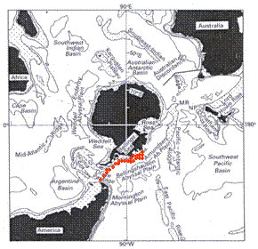
Argo profiling floats will be deployed during the SIMBA cruise. A total of 23 floats will be deployed along the cruise track from Punta Arenas to the Amundsen Sea. These floats will drift at a depth of 1000 meters; at 10-day intervals, each float will sink to a depth of 2000 m and then ascend to the sea surface over a period of approximately 6 hours, collecting a CTD profile as it ascends. Many of the floats are also equipped with dissolved oxygen sensors. Once on the sea surface, the floats will transmit their data to a satellite and descend again to 1000 m to begin another 10-day cycle. Each float is capable of collecting 200 or more profiles in this manner. The floats are equipped with ice-avoidance software in order to decrease the probability that they will be crushed by drifting ice while transmitting on the sea surface. As the floats ascend between depths of 50 and 30 meters, they examine the median temperature in this depth range; if the temperature is below a critical temperature that is indicative of ice cover above (chosen to be -1.77°C), the float will turn off its buoyancy pump in order to stop its ascent. In such a case, the float will decelerate and then stop at a depth of about 3 meters; the float will then store the data collected and descend back to 1000 m. This process will continue for as many profiles and 10-day intervals as necessary until the float is able to reach the sea surface, at which time it will transmit all stored profiles. Each float can store as many as 70 high-resolution profiles in this manner, or nearly 2 years' worth of data. The floats all use the relatively high-bandwidth Iridium satellite system for communication.
After the Palmer departs Punta Arenas, floats will be deployed in Drake Passage and then along the ice edge, near the 2000 m isobath. A few floats will be reprogrammed so that they can be deployed in shallower water on the Amundsen Sea shelf, where the ice cover is more permanent. The goal of this work is to begin to extend the Argo array into ice-covered waters and to sample the high-latitude water column below sea ice under winter conditions. An analogous array of 23 floats, also supplied by the University of Washington, will be deployed in the Antarctic south of Australia during the same time frame from the vessel Aurora Australis.
Marine Mammal Research
Participants: Brent S. Stewart, Pamela K. Yochem
We will conduct systematic surveys of the relative abundance and distribution of whales, dolphins, and seals throughout the SIMBA expedition. We will also make detailed observation of the breeding biology of crabeater, Ross,and leopard seals. Little is known about the biology and ecology of these species, particularly during the breeding season when access to their ice associated habitats in spring is difficult. We will collect tissue samples to evaluate health and nutrition, reproductive status, and population genetics and immunogenetics. We will outfit seals with small satellite-linked radio transmitters that will allow us to track their movement after the breeding season for a year or more. This research will provide substantial new information on the reproductive biology, foraging ecology, habitat requirements and use, migratory patterns, disease and pathology and medicine, and population and immunogenetics of the four ice-associated phocid pinnipeds (crabeater, Ross, leopard, and Weddell seals). It will provide this information for the first time for these species in the BeAR sea ice mass massif (i.e., Amundsen and Bellingshausen seas) area, one of the two principal areas in the Antarctic of abundant persistent sea ice in summer and consequently perhaps the most important area for these ice breeding marine mammals, particularly as southern ocean climates warm and annual ice cover recedes generally and seasonal sea ice in other areas may become unsuitable for reproduction of these species. These physical and biogeochemical dynamics of sea ice are central to the biology and ecology of the four Antarctic phocid pinnipeds that depend on it as substrate to support breeding, molting and resting activities and for the trophic stimulation and enhancements that are association with seasonal melting. We expect to gain new information on the importance of variation in the mass balance of sea ice to variability in the distribution, reproductive success, foraging success, health, and population integrity and relationships of these ice-associated seals, particularly for crabeater, Ross, and leopard seals, and new comparative information on the life histories of these species in the BeAR Sea Ice massif relative to other areas of the Antarctic where these pinnipeds have been studied.
Swath Bathymetry
Participants: S.F. Ackley PI, Kathleen Gavahan
The Amundsen Sea area, because of ice cover and remoteness, has not been the subject of intensive study of its fundamental properties, including bathymetry. We will therefore use the swath bathymetric system on NB Palmer while underway to fill in some of the blanks in bottom topography and bottom characteristics. Data will be coordinated with J. Anderson, Rice University, and Julian Dowdeswell, Scott Polar Research Institute, to provide more complete bottom mapping of the region by combining this swath information with that from previous cruises of NB Palmer and JC Ross in the region. Particular features of interest are the depressions and channels on the shelf and continental slope which have origins in glacial meltwater erosion at the retreat of the last ice age and, on the shelf, are thought to be pathways for warm deep water to access the subglacial cavities of Pine Island Glacier, Thurston Glacier and other glaciers. The warm waters are hypothesized to be a source for the excess melting recently observed for these West Antarctic glaciers and ice shelves.
Education and Outreach
Participants: Sarah Anderson, S.F. Ackley
PolarTREC is an educational research experience, funded by the National Science Foundation and managed by the Arctic Research Consortium of the U.S., in which K-12 teachers participate in polar research, working closely with scientists as a pathway to improving science education (www.polartrec.com). In celebration of the International Polar Year (2007-2009), thirty-six U.S. teachers will spend two to six weeks working with a research team in the Arctic or Antarctic. While on field expeditions, teachers and researchers will share their experiences with scientists, educators, communities, and hundreds of students of all ages across the globe. PolarTREC builds on the strengths of the past TREC program (Teachers and Researchers Exploring and Collaborating in the Arctic) to encompass learning experiences in both the Arctic and Antarctic.
Sarah Anderson will join researcher Stephen Ackley on the two month cruise on the research icebreaker Nathaniel B. Palmer in the Bellingshausen-Amundsen Sea in western Antarctica. As described under other projects, the group will sample the sea ice, ocean, atmosphere, and biology to investigate sea ice properties and processes and their interaction with these other environments and deploy an array of 12-14 drifting buoys that will continue to measure these processes for an additional year. Sarah's research participation will include ice and marine mammal observations during the transects of the cruise and time series observations of ice thickness changes at a set of sites on the drift station phase of the cruise. As well as her outreach activities in sharing an email journal and communicating with students and teachers nationally and internationally. Sarah's students in Boerne, Texas will follow the expedition through the online journals, webinars, and email correspondence. Sarah will be supported during the expedition by a team of teachers in Boerne that will help students throughout the district gain access to cutting-edge polar research and bring authentic polar science to the classroom.

Sarah Anderson
Teacher
Boerne High School

Stephen Ackley
Researcher
The University of Texas at San Antonio
Ice Observations
Participants: P. Wagner, J. Pena, S. Anderson, K. Leonard, S. Stammerjohn, B. Saunders, M. VanCoppenolle, G. Carnat, N. Geilfus, F. Brabant
ASPeCt is an expert working group of the Scientific Committee of Antarctic Research (SCAR) whose aim is to help improve and standardize our understanding of the Antarctic sea ice zone through ongoing field programs, remote sensing and numerical modelling. The data will be recorded manually and transcribed into electronic format, following the ASPeCt protocol, for inclusion in the cruise data set. Although the observations are necessarily subjective to each person's individual biases, when taken as a whole, the data set will reveal some statistically valid trends in winter sea ice conditions of Western Antarctica in the Bellingshausen/Amundsen Sea.
- Final Cruise Report for the Ice Observations
- ASPeCt Ice Observations
- Ice Conditions Trends for Palmer Station and Belgica
Radiation and Meteorology
Participant: Martin VanCoppenolle
Radiation and meteorology data will be monitored to establish the distribution of the basic physical properties of sea ice that contribute to air-sea interaction sea ice features. A series of meteorological, radiation, and snow measurements will be performed and/or analyzed during the cruise. We will study if weather is driven by the wind direction and by the continental or oceanic origin of the air masses. Since cloudiness has a tremendous control on the radiative fluxes and on the surface albedo, ship-based observations (SHIP) of wind, temperature, relative humidity, and radiation will be collected. Also this will help to study the relationship of cloud cover information from the radiative fluxes. Data sets will be derived from ship-based observations, in situ measurements, visual hourly observations, and measurements of snow depth, and albedo made at sites in the final ice station.
Remote Sensing
Participants: Burcu Cicek, Hongjie Xie, John Pena
Current sea ice conditions from all satellite imagery used for SIMBA
- AMSR-E August-September-October, 2007
- AMSR-E September-October, 2007 (provided by the National Ice Center)
- Envisat August-September-October, 2007
- Quickscat August-September-October, 2007
- Envisat High Resolution Image (provided by Polar View)
Product will be provided by: NIC. Resized image size: few hundred kb (jpeg format). Will be provided to ship: 17 images (expects to receive two images per week). A Radarsat email account will be established on the NBP ( radarsat@nbp.usap.gov) specifically to receive images. Our order of Radarsat 2 depends on its launch. You can find the information below radarsat2.info/application/ice/key_features.asp.
Sea Ice Edge and Ice Concentration |
HH and HV |
§ HV improves the detection of the ice edge. |
Ice |
HH and HV |
§ HH/HV ratio could improve discrimination of multi-year ice from first year ice (multi-year provides strong depolarized response while first year does not). |
Ice |
HH and VV |
§ Co-polarized ratio provides the best distinction between thin and new ice types from open water. This combination is available using quad-polarized data (narrow swath width) and will benefit specific regions-of-interest. |
Sea Ice Topography and Structure |
HV |
§ Improved ice topography and structure information. |
Icebergs |
HV |
§ Advantageous for detecting icebergs particularly at steeper incidence angles (below 35 degrees) and in higher sea states. |
DMSP SSM/I Daily and Monthly Polar Gridded Sea Ice Concentrations (Passive Microwave)
Resized image size: 30kb (jpeg format). Will be provided to ship: Daily.
Parameter: Total and multiyear sea ice concentration |
|
Algorithm: NASA Team; Bootstrap |
|
Source: SSM/I F-8, SSM/I F-11, SSM/I F-13 |
Projection: Polar stereographic |
Temporal Coverage: Ongoing since July 1987 |
Temporal Resolution: Daily and monthly |
Spatial Coverage: North and south polar regions |
Spatial Resolution: 25 km true at 70 degrees latitude |
Data Format: HDF |
|
AMSR-E/Aqua Daily L3 12.5 km Tb, Sea Ice Concentration, & Snow Depth Polar Grids (Passive Microwave)
» AMSR-E/Aqua data set
Resized image size: 20kb (jpeg format). Will be provided to ship: Daily.
Parameter: Brightness temperatures, sea ice concentration, sea ice concentration differences between enhanced NASA Team (NT2) and Bootstrap Basic Algorithm (BBA), snow depth over sea ice |
|
Source: AMSR-E sensor aboard NASA's Aqua satellite |
Projection: Polar stereographic |
Temporal Coverage: 18 February 2004 through near-present |
Temporal Resolution: Daily |
Spatial Coverage: North and south polar regions |
Spatial Resolution: 12.5 km |
Data Format: HDF-EOS |
|
The 12.5 km sea ice concentration product is generated using two algorithms: the enhanced NASA Team (NT2) algorithm (Markus and Cavalieri 2000) for the Arctic and the Bootstrap Basic Algorithm (BBA, Comiso 1995) for the Antarctic. |
|
MODIS/Aqua Sea Ice Extent 5-Min L2 Swath 1km (Visible)
Resized image size: Not known. Will be provided to ship: Due to lack of sunlight those images won't be available.
Band 3,6,7 Combination: Long Answer
The 3-6-7 composite assigns Bands 3, 6, and 7 to the red, green, and blue components of a digital image. This combination is good for revealing snow and ice because they are very reflective in the visible part of the spectrum, and very absorbent in Bands 6 and 7, which are a part of the spectrum called the short-wave infrared, or SWIR.
Snow and Ice
Since the only visible light used in these images (Band 3) is assigned to red, snow and ice appear bright red. The more ice, the stronger the absorption in the SWIR bands, and the more red the color. Thick ice and snow appear vivid red (or red-orange), while small ice crystals in high-level clouds will appear reddish-orange or peach.
Band 3,6,7 Combination: Short Answer
Bands
3,6,7 (479 nm: 1,652 nm: 2,155 nm)
Colors
vegetation=green
ice or snow=red
liquid water on the ground=black or dark red
liquid water clouds=white
ice clouds=peach
desert=light blue-green
Advantages
Distinguishing liquid water from frozen water, for example, clouds over snow, ice cloud versus water cloud; or floods from dense vegetation
Envisat ASAR
Product can be downloaded from: http://www.seaice.dk/polarview/. File size: 163 kb (zip file includes jpeg file). Will be provided to ship: Daily
QuikScat
» QuikScat data set
Product can be downloaded from: http://www.seaice.dk/polarview/. File size: 24 kb (zip file includes gif file-image below shows May 17, 2007). Resolution: The resolution of the QuikScat images is about 10 kilometers, and the pixel spacing is 6 kilometers. Will be provided to ship: Daily.
The QuikScat data are given as backscatter coefficient in dB (log scale). The QuikScat instrument is a conically scanning radar that transmit and receive at both horizontal and vertical polarization. (HH is for transmitted and received horizontal polarization, VV for vertical). The POL images are the ratio of VV to HH. The HH and VV images are rather similar. Over the ocean the signals are strongly correlated with wind speed. Over the ice, the signal is more associated with ice type than ice concentration [older ice stronger backscatter (red)]. Processes in the snow (grain size etc. can generate stronger backscatter (red areas) as well.
The POL image normally gives a reasonable reliable ice extent (maximum limit of the ice).
SIMBA Event Log
The SIMBA Event Log lists all activities conducted on the SIMBA cruise. For easy navigation, event numbers are issued according to time and day.


