Mapping and Ground-Truthing Populations of Bigtooth Maple in Bandera and Real Counties, Texas
Project Description
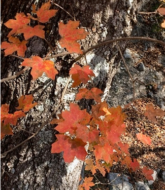
The projects's objectives are to:
- Locate populations of bigtooth maple on 15 properties in Bandera and Real counties in central Texas.
- Map the populations when their leaves change colors during the fall using an Unmanned Aircraft (UA).
- Estimate density and basal area of bigtooth maple and associated woody species in the spring after leafing out using the quadrat procedures to ground-truth.
- Determine the accuracy of the UA in estimating bigtooth maple by comparing UA and ground-truthing estimates.
The results will provide baseline natural history information for bigtooth maple woodlands in the Edwards Plateau, and evaluate the potential of using unmanned aircraft to facilitate more efficient and rapid assessment of bigtooth maple woodlands and other plants that are species of greatest conservation need.
Project Contacts
Principal Investigator
Dr. Janis K. Bush
Professor and Chair, Department of Environmental Science and Ecology, The University of Texas at San Antonio
Janis.Bush@utsa.edu | 210-458-5660
Co-Principal Investigator
Dr. O. W. Van Auken
Emeritus Professor, Department of Environmental Science and Ecology, The University of Texas at San Antonio
Drone and GIS Specialist
Ms. D. L. Taylor
Cisebsi Ltd. Co.
Project Collaborators and Partners


